 My Dream Peaks
Hut
Refuge Temple Écrins
2,410 m · Isère · France
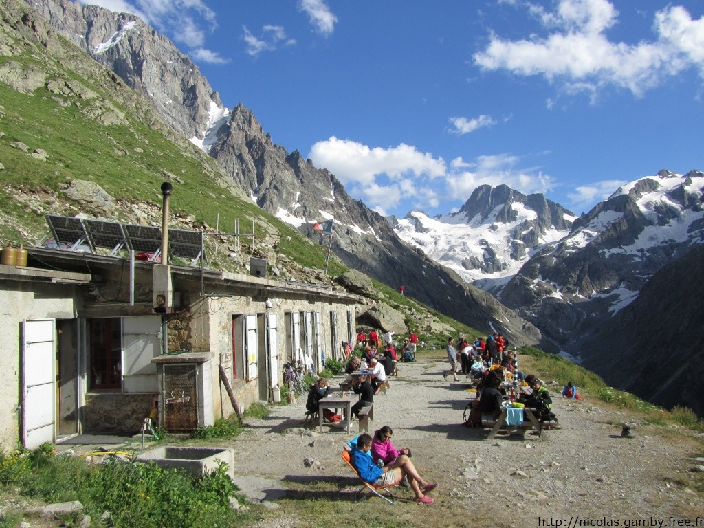
A staffed FFCAM hut on the grassy slopes above the upper Vénéon valley in the Écrins massif, under the Barre des Écrins and Pic Coolidge, inside the core of the Écrins National Park. It is a squat, partly buried concrete building reached from La Bérarde in about 2½ hours. Climbers use it for Pic Coolidge, the Col de la Temple crossing to the Vallouise side and the traverse of the Barre des Écrins; walkers come for the glacier views and the chamois that often graze near the terrace.
Staffed in season · early June – mid-September (2026: 6 June – 13 September); weekends in May on booking · 48 beds · winter room
History and people
Run by FFCAM (Fédération française des clubs alpins et de montagne), Isère refuge commission.
- 1927 First hut inaugurated about 40 m above today's site (the FFCAM gives 1928 for its construction; its foundations can still be seen). ↗
- 1935 The first hut was damaged by a snow slide and repaired. ↗
- 1938 An avalanche carried the first hut away for good. ↗
- 1941 Rebuilding started lower down with help from the Jeunesse et Montagne association; the new hut (64 places) was finished in 1948. ↗
- 2018 Fully renovated by the FFCAM: places cut from 64 to 48, new dorms and washrooms, a brighter dining room, solar panels on the north roof. ↗
Good to know
- The 2018 renovation deliberately reduced the hut from 64 to 48 places to make room for smaller dorms, more washrooms and a separate space where school groups of minors can sleep. ↗
- After the floods of June 2024 the hamlet of La Bérarde, the usual start, has been closed to visitors; from 1 September 2026 cars may drive only as far as Les Étages, with drop-off allowed at the entrance to La Bérarde and bypass paths to the trails. ↗
- Outside the staffed season a part of the hut stays open: a dorm with mattresses and blankets, but no heating, gas, lighting or water; in winter you may have to enter through the top of the door. ↗
- Bivouac is allowed near the hut (core zone of the national park) from 19:00 to 09:00 on grassy pitches, with water and toilets at the hut. ↗
Getting there and climbing from here
- From La Bérarde (1,730 m) · Path up the right bank of the Vénéon past Plat du Carrelet, left at the 1,948 m fork (right goes to Refuge de la Pilatte), then steep zigzags through forest to the grassy slopes; about 6 km · about 2.5 h, +700 m
- From Vallouise side (Refuge du Glacier Blanc / Pré de Madame Carle) · Over the Col de la Temple (glacier crossing, grade F)
Base for: Pic Coolidge (normal route PD-) · Barre des Écrins (traverse, AD) · Dôme de Neige des Écrins (Young routes AD, Brèche Lory PD+; early season) · Ailefroide (listed by French Wikipedia among the routes from the hut)
Staying: Online on the hut's FFCAM page, or by phone; unstaffed nights (25 places) are paid afterwards online. ↗
Peaks it serves
- Barre des Écrins 4,102 m · last night before the summit
- Dôme de Neige des Écrins 4,015 m · last night before the summit
- Brèche Lory 3,974 m · last night before the summit
- Col de la Lavey 3,309 m · last night before the summit
- Ailefroide 3,954 m · 2.8 km away
- Mont Pelvoux 3,946 m · 4.8 km away
- Pic Sans Nom 3,913 m · 4.2 km away
- Pic Coolidge 3,775 m · 2.0 km away
Routes
- Barre des Écrins: Coup de Barre, j'Écrins le pire! last night here · ED+
- Barre des Écrins: Goulotte Gabarrou - Marsigny last night here · ED
- Barre des Écrins: Dôme de Neige des Écrins : Petite Traversée des Écrins par le versant S de la Brèche Lory last night here · PD+
- Dôme de Neige des Écrins: Petite Traversée des Écrins: south side of the Brèche Lory from Temple-Écrins last night here · PD+
- Dôme de Neige des Écrins: Couloir Young (original Young route), S/W side last night here · AD, 4a, engagement III
- Dôme de Neige des Écrins: Petite Traversée des Écrins par le versant S de la Brèche Lory last night here · PD+
- Brèche Lory: Barre des Écrins : Coup de Barre, j'Écrins le pire! last night here · ED+
- Brèche Lory: Dôme de Neige des Écrins : Petite Traversée des Écrins par le versant S de la Brèche Lory last night here · PD+
- Col de la Lavey: Traversée des Écrins : Pré de Madame Carle → Villar-Loubière last night here · PD-
Weather forecast
Loading forecast…
More forecasts: Météo-France mountain · yr.no · meteoblue · Windy · Mountain-Forecast.com
Avalanche danger: Météo-France avalanche risk — always read the current bulletin.
Map
Nearby: Bivouacs du Glacier de la Temple bivouac · 3,000 m · 1.2 km · Refuge du Carrelet hut · 1,909 m · 1.4 km · Bivouac du col de la Temple bivouac · 3,321 m · 1.9 km · Bivouac Tête Rouge - Pilier S Barre Écrins bivouac · 3,573 m · 2.6 km · Bivouac 3300m Pilier S barre des écrins bivouac · 3,300 m · 2.6 km · Glacier de Bonne Pierre glacier · 2,470 m · 3.0 km · Bivouac de Bonne Pierre bivouac · 2,945 m · 3.4 km · Refuge de la Pilatte hut · 2,572 m · 3.8 km
Links
Sources
Researched 2026-11-15 (high confidence) from: fr.wikipedia.org/wiki/Refuge_Temple-%C3%89crins · www.wikidata.org/wiki/Q120312859 · refugetempleecrins.ffcam.fr/ · refugetempleecrins.ffcam.fr/acces.html · refugetempleecrins.ffcam.fr/le-mot-du-gardien.html · www.ffcam.fr/renovation-refuge-temple-ecrins.html · www.temple-ecrins.com/refuge-pratique/hors-sa... · www.oisans.com/acces-a-la-vallee-du-veneon/ · www.camptocamp.org/waypoints/104028 · api.camptocamp.org/waypoints/104028 · www.camptocamp.org/images/232786
Camptocamp (CC BY-SA)