 My Dream Peaks
Hut
Refuge de l'Alpette
1,500 m · Isère · France
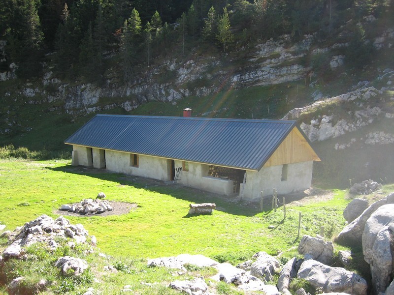
A free, unstaffed stone hut owned by the commune of Chapareillan, on the grassy Alpette pasture plateau at the northern end of the Chartreuse massif, a few minutes from the Col de l'Alpette and just south of Mont Granier. It sleeps about 20 on a wooden platform and in a mezzanine, with a wood stove inside. Walkers come up from the hamlet of La Plagne (Entremont-le-Vieux) in about an hour, and it is a handy night out before Mont Granier or a crossing of the Chartreuse high plateaux.
Not staffed · open all year (free hut) · 20 beds
History and people
Run by Commune of Chapareillan (owner); unstaffed, free to use.
- 2010 Renovated by the commune of Chapareillan (work finished in the autumn of 2010), with a sleeping mezzanine added. ↗
Good to know
- Firewood is left at the hut; cutting or collecting wood around it is not allowed. ↗
- A spring about 30 m from the hut usually runs, but visitors have sometimes found it dry, so carry some water or a way to treat it. ↗
- The plateau is summer grazing ground: walkers report cattle, marmots and ibex around the hut, and Mont Blanc in view on clear days from the nearby high point. ↗
Getting there and climbing from here
- From La Plagne hamlet, Entremont-le-Vieux (about 1,090 m) · GR 9 up through the forest to the Col de l'Alpette, then a few minutes to the hut · about 1 h
- From Grésivaudan valley (Chapareillan side) · steep path up the Isère-side slopes · about 2.5 h
- From Col de Bellefont, Chartreuse high plateaux · north along the high plateaux · about 5.5 h
Base for: Mont Granier (the Granier routes via the Porte de l'Alpette pass close by) · Le Pinet (Le Truc) (about 1 km away, a view point over Mont Granier)
Staying: No booking and no meals; first come, first served. Bring a sleeping mat: the number of mattresses varies. ↗
Peaks it serves
- Mont Granier 1,933 m · last night before the summit
- Sommet du Pinet 1,867 m · last night before the summit
- Mont Joigny 1,558 m · last night before the summit
Routes
- Mont Granier: Traversée de la Chartreuse : N>>S Du Mont Granier à la Dent de Crolles - version hivernale/printanière last night here
- Mont Granier: Traversée Pas des Barres >> Pas de la Porte last night here · T3
- Sommet du Pinet: Sommet du Pinet ou le Truc : Par le col de l'Alpette (été/hiver) last night here · T2
- Mont Joigny: Chambery - Gorgeat - Joigny - Tencovaz - Col de l'Alpette last night here · T2
Weather forecast
Loading forecast…
More forecasts: Météo-France mountain · yr.no · meteoblue · Windy · Mountain-Forecast.com
Avalanche danger: Météo-France avalanche risk — always read the current bulletin.
Map
Nearby: La Ferme de l'Ours lodge · 1,096 m · 1.2 km · La Plagne (Chartreuse) trailhead · 1,096 m · 1.3 km · Sainte-Marie du Mont - Pré Orcel trailhead · 1,405 m · 2.4 km · Tencovaz trailhead · 1,085 m · 3.1 km · Gîte le chalet de la Hulotte lodge · 1,000 m · 3.1 km · Entremont le Vieux trailhead · 850 m · 3.2 km · Sainte Marie du Mont - Les prés trailhead · 930 m · 4.0 km · Col du Granier trailhead · 1,134 m · 4.6 km
Links
Sources
Researched 2026-11-15 (medium confidence) from: www.camptocamp.org/waypoints/238843 · www.refuges.info/point/81/cabane-non-gardee/c... · www.randozone.com/fiche/13045/refuge-de-l-alp... · www.visorando.com/randonnee-col-de-l-alpette/
Camptocamp (CC BY-SA)