 My Dream Peaks
Day 14 · Tuesday 17 November 2026
Glaciers, lakes and waterfalls get pages, weather at every hut, a tidier rank list
Sights get their own pages with size facts and glacier outlines, every hut, camp and sight gets a forecast with sunrise and sunset, and the rank page fits each peak on one line.
Day fourteen was about the places around the peaks. A walk often goes to a glacier, a lake or a waterfall rather than a summit, and members' tracks already pass thousands of them. So the sights got proper pages, every place page got the same forecast as a peak, and the rank page got a cleaner look.
Sights get their own pages, and glaciers their outlines
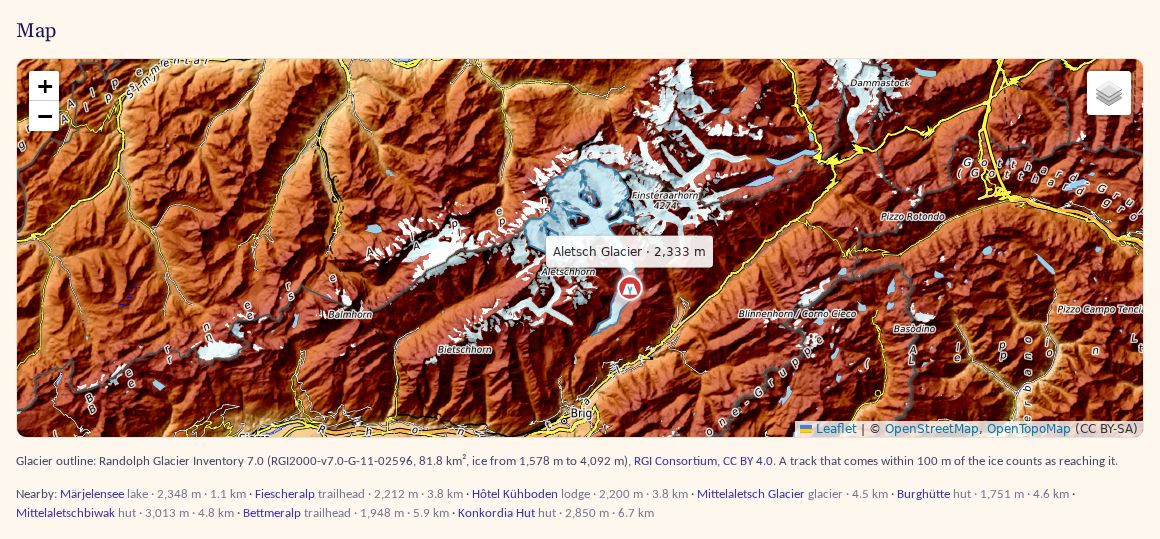
We keep about 27,000 sights from Wikidata: waterfalls, viewpoints, glaciers, lakes, natural arches, caves and volcanic craters. Until now their pages looked like a hut's. Now a sight's page shows its size where Wikidata gives one (Area, Length, a waterfall's Drop, a lake's Deepest point), a Read on Wikipedia button and Peaks nearby, the summits around it. The Aletsch Glacier, for example, shows 118 km² and 22.8 km. The best-known sights are first in line for a short AI summary. On every map, sights got their own markers, grouped as water, ice, rock and views, so a lake no longer looks like a hut.
Glaciers got more. We matched the outlines from the Randolph Glacier Inventory 7.0 (CC BY 4.0) to the glaciers we know, and a glacier's page now draws its ice on the map, with its area and the height range of the ice. The outlines also decide when your track reached a glacier: within 100 m of the ice, at about the ice's height there. Before the outlines came in, Peter asked for a tighter rule than "somewhere near the glacier's point", and the outlines made it exact. Two glaciers, the Polish Glacier on Aconcagua and Larsbreen on Svalbard, had their Wikidata points sitting on other glaciers; we fixed those by hand.
The places themselves now come from our own monthly Wikidata extract rather than live queries, and a daily job loads a fresh copy and matches members' tracks to it again.
Weather, sunrise and sunset at every place
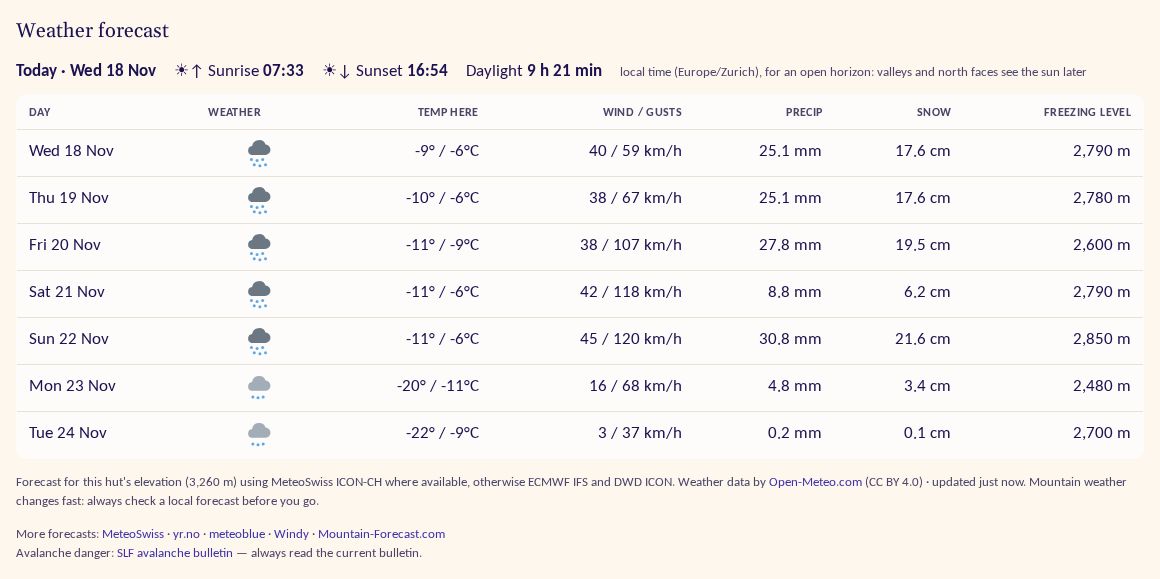
Peaks have had a 7-day forecast for a while. Peter wanted the same everywhere ("consistency"), so every place page, huts, camps, trailheads, villages and sights, now has the same Weather forecast, with the same models and limits as on peaks, worked out for the place's own elevation (or the terrain height there when we don't know it). The table header says "Temp here" instead of the summit's temperature.
Above the forecast, on both peak and place pages, there is now a line for today: sunrise, sunset and the hours of daylight, in local time. North of the Arctic Circle it says polar night or midnight sun instead.
The rank page, one line a peak
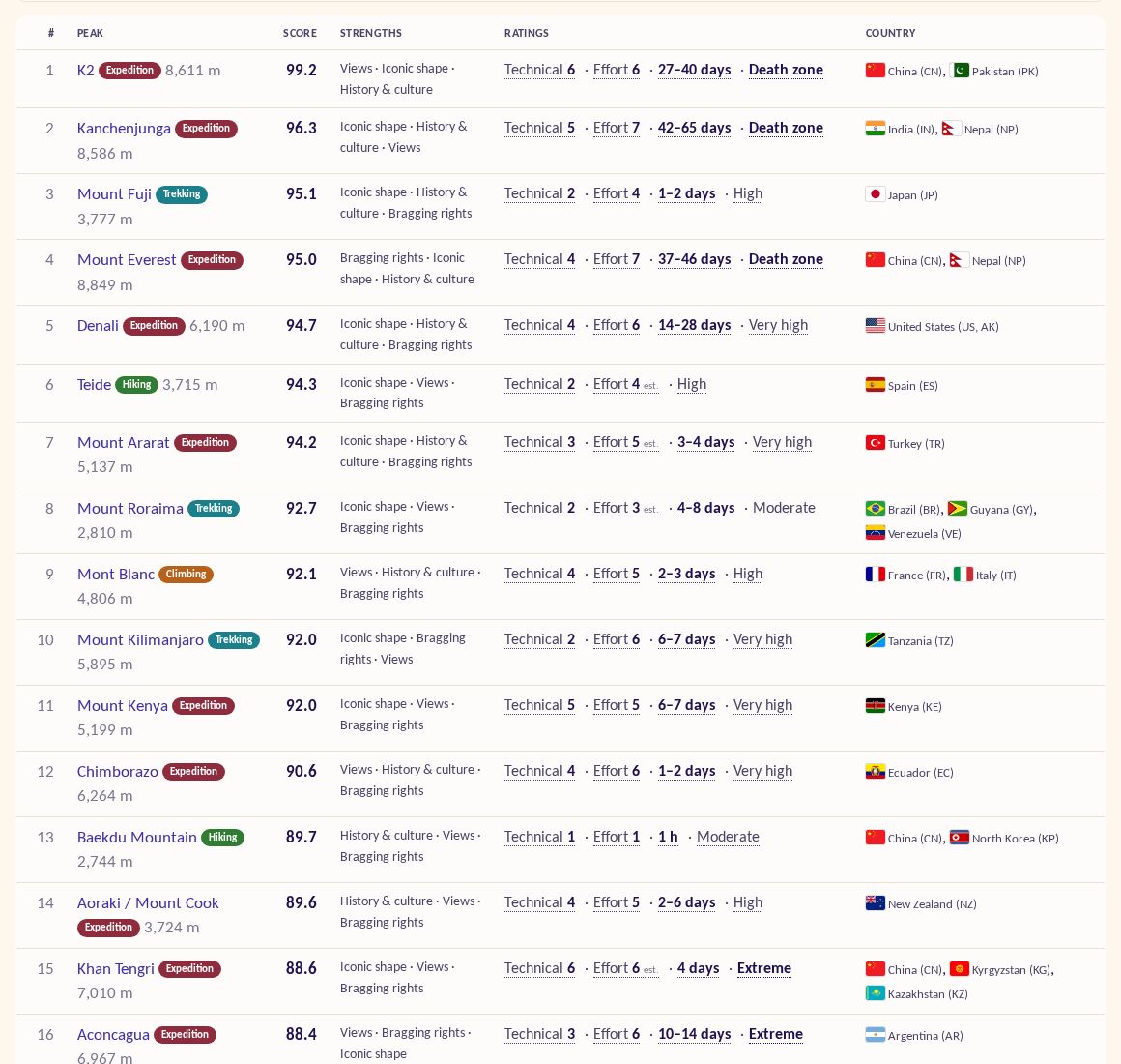
The rank page sorts researched peaks by what you care about: views, fame, difficulty, solitude and more. Its rows had grown tall, with tags, score bars and a block of ratings. Out of several layouts we suggested, Peter chose one line a peak. The category sits next to the name, the strengths are a short line of text, and the ratings are reduced to Technical, Effort, days on the mountain and altitude. The full explanations stay in the tooltips and on the peak page.
Also
- Places visited without GPS: when editing a trip, you can look around a summit or place of the trip (2–20 km, 5 by default), tick the sights, huts and camps you saw and pick the day.
- Rivers on trip days and in "On the way" can be clicked to show the river on the map.
- Join is now at the top of every page for visitors; profiles show 15 peaks and timeline items with "Show all"; on phones the peak header puts the photo under the height and shortens the range chain.
- Trips are more private: joining a trip shows only the climbs and hut stays you may see, and a trip's day titles are built only from those.
- Clicking a search suggestion on a page with photos no longer opens the slideshow (reported by a member).
- Fixes from a security review, newer libraries, and email alerts for site problems.
- Research: 60 sights and 54 trailheads that members' tracks reached, with local-language sources: getting there, parking, permits and closures.